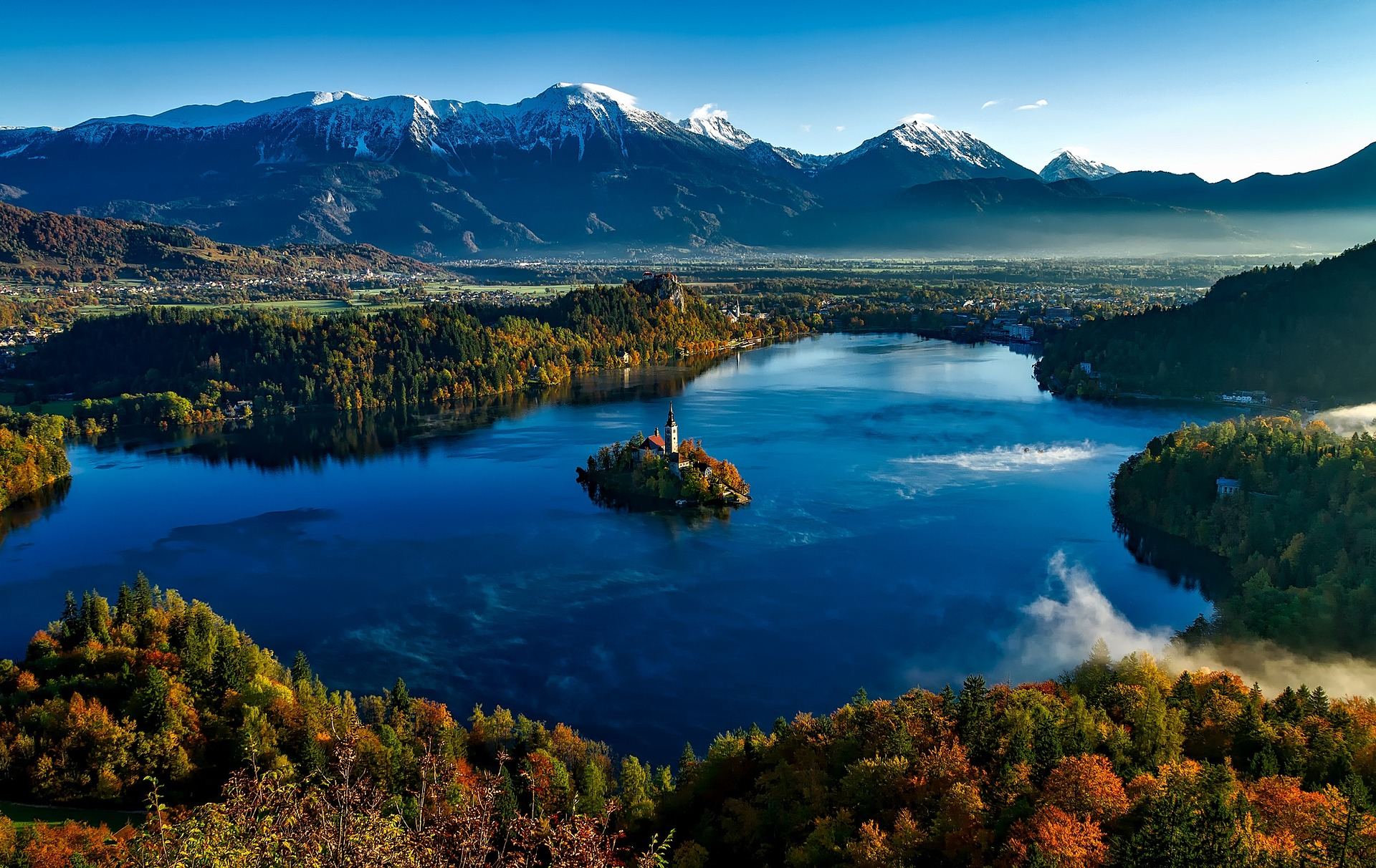
Lake Bled and its island church, ringed by autumn woods, with a line of snowy mountains behind.
Slovenia is a small country between the Alps and the Mediterranean. The Julian Alps rise in the northwest, and to the southwest lie the limestone Karst plateau and a short stretch of coast. More than half the country is forest, so green scenery follows you wherever you ride.
The country is so compact that a day or two takes you from the mountains to near the sea, and the drive from the capital, Ljubljana, to Lake Bled takes less than an hour. Quiet country roads and bike paths link the villages, which makes it easy to string several regions together on an e-MTB that helps you up the climbs.
This guide centres on the signature Lake Bled loop and covers five regions: Bled, Lake Bohinj, the Vršič pass, the Soča valley and the Karst plateau, with the roads and sights of each.
Gorenjska · Bled, lake at about 475 m
Lake Bled Forest Loop
- Distance
- About 45–50 km (about 500 m of climbing)
- Time
- Day trip
- Surface
- Paved road plus forest and gravel tracks
- Level
- Beginner
Bled is a small lake shaped by glaciers. A church stands on a tiny island in the middle, and a castle looks down from the top of a cliff on the north shore. With the Julian Alps and the Karavanke range behind, it is the view that appears most often in pictures of Slovenia.
A lap of the lake is only about 6 km and flat, a good warm-up even for first-time e-MTB riders. This route adds forest tracks and village lanes, passing the entrance to Vintgar Gorge north of Bled and heading up the Radovna valley. The climbs are short and gentle, which makes it the easiest of the five routes.
The Radovna valley lies inside Triglav National Park. In the park you may only cycle on paved roads and routes marked for bikes, so stay on the road through the valley. It runs quietly past a clear river, meadows and old farmhouses.
Things to see
Bled Island church
You cross from the shore in a pletna, a traditional wooden boat. From the landing, 99 stone steps lead up to the church.
Bled Castle
A castle on top of the cliff above the lake. From its walls you see the lake, the island and the Julian Alps in the distance.
Vintgar Gorge
A narrow gorge carved by the Radovna river, explored on wooden walkways fixed to the cliffs. It is a walking route, so leave your bike at the entrance and go on foot.
Kremšnita
Bled's famous cream cake: thick layers of custard and whipped cream between thin pastry. Try it at a lakeside café after the ride.
Triglav National Park · lake at about 525 m
Lake Bohinj and the Sava Valley
- Distance
- About 60 km return from Bled
- Time
- Day trip
- Surface
- Paved road plus bike paths
- Level
- Beginner to intermediate
Bohinj is Slovenia's largest natural lake, about 25–30 km west of Bled. It lies inside Triglav National Park, so there are no big buildings on the shore, and high mountains come right down to the water. It feels much quieter and more remote than Bled.
From Bled, the road follows the Sava Bohinjka river up the valley on a gentle climb. A road runs along the south shore of the lake to Ukanc at the western end; the north shore is a footpath, so bikes use the southern road.
The small stone bridge and church at the eastern end are the classic Bohinj view. The path to Savica waterfall starts at the western end, and a cable car from the southwest end of the lake lifts you high enough to see the whole lake from above.
Things to see
Church of St John the Baptist and the stone bridge
A small church at the eastern end, where the lake flows out into the river. From the bridge you can fit the church, the lake and the mountains into one frame.
Savica waterfall
A waterfall in the woods above the western end of the lake. The last stretch is a stepped path, so leave the bike and walk up.
Vogel cable car
A cable car up the mountain south of the lake. On a clear day you can see across to the peaks around Triglav.
Bohinj cheese
This valley has long made cheese on its summer pastures. Village shops sell local cheeses to try.
Kranjska Gora to Trenta · pass at about 1,611 m
Vršič Pass Across the Julian Alps
- Distance
- About 50 km, Kranjska Gora to Bovec (about 800 m of climbing)
- Time
- Day trip
- Surface
- Paved pass road (some cobbled hairpins)
- Level
- Advanced
Vršič is Slovenia's highest road pass. It crosses the heart of the Julian Alps, linking Kranjska Gora in the north with the Soča valley in the south. Russian prisoners of war built the road during the First World War, and its 50 hairpins, counting both sides, are each numbered.
The climb from Kranjska Gora is short but steep, and some hairpins are paved with cobbles. It is a hard pass on a regular bike, but the distance is short enough that an e-MTB can use a higher assist level and still get up comfortably. At the top, rock peaks rise right beside the road.
Over the top, a long descent leads into the Trenta valley where the Soča river begins. The road crosses Triglav National Park, so do not leave it for mountain paths. Carry on to Bovec at the bottom and you join the Soča valley route in the next section.
Things to see
Russian Chapel
A small wooden chapel built in memory of Russian prisoners killed by an avalanche while building the road. It stands in the woods on the Kranjska Gora side of the climb.
Lake Jasna
A small lake near Kranjska Gora, where the pass road begins. A good place to warm up before the climb.
Source of the Soča
On the Trenta side, a short walk up a mountain path leads to the spot where the Soča springs from the rock. Leave the bike by the road and go on foot.
Primorska · Bovec, Kobarid and Tolmin, about 200–450 m
The Emerald Soča Valley
- Distance
- 30–50 km per day
- Time
- 1–2 days
- Surface
- Paved road plus riverside gravel
- Level
- Beginner to intermediate
The Soča is famous for water so clear and green it looks like emerald. It rises in the Julian Alps and flows south through deep valleys, drawing rafters and kayakers. The villages of Bovec, Kobarid and Tolmin line its course.
Following the river downstream is mostly downhill or flat, so the riding is easy. Leave the main road for the lanes and gravel tracks on the far bank to avoid traffic and see more of the river. Bovec is also a base for mountain bike rides into the surrounding hills.
During the First World War this valley was a battleground on the Isonzo Front. The museum in Kobarid and the trenches and forts left on the hillsides tell the story of that time.
Things to see
Kobarid Museum
A museum on the history of the Isonzo Front. The retreat described in Hemingway's novel A Farewell to Arms took place in this area.
Kozjak waterfall
A waterfall near Kobarid that drops into a cave-like hollow surrounded by rock. The last stretch is on foot.
Kluže Fortress
An old fort above a deep, narrow gorge near Bovec. From the bridge you can look straight down into the gorge.
Tolmin Gorges
Narrow gorges above Tolmin where two rivers have cut into the rock, at the southern entrance to Triglav National Park. You explore them on foot.
Primorska · Kras plateau, about 300–500 m
Stone Villages of the Karst Plateau
- Distance
- 40–60 km per day
- Time
- 1–2 days
- Surface
- Quiet paved roads plus gravel
- Level
- Beginner to intermediate
The Kras is a limestone plateau on the border with Italy. Landscapes where rainwater sinks underground and forms caves and hollows are called 'karst' all over the world, and the word comes from this region. Above ground you find red soil, stone walls and vineyards; below it, huge caves.
The plateau has little height difference, so the riding rolls gently, and quiet country roads link stone villages. Most villages have a small family winery, which suits a slow day of stopping to taste the local food.
Nearby are the Škocjan Caves, a UNESCO World Heritage site, and the much-visited Postojna Cave. Caves are explored on foot with a guide, so it is worth giving the bike a day off for a cave visit.
Things to see
Škocjan Caves
A vast underground canyon carved by the Reka river as it disappears below ground. It became a UNESCO World Heritage site in 1986.
Lipica
An old stud farm founded in the 16th century, home of the white Lipizzaner horses. Wide pastures and tree-lined lanes surround it.
Štanjel
An old hilltop village of stone houses stacked in tiers. From the top you look out over the Kras and the valleys around it.
Teran and pršut
Teran, a red wine from grapes grown in red soil, and pršut, ham dried in the plateau wind, are the local specialities.
Good to know before you go
When to go
May to September. The Vršič pass opens only once the snow has gone, and from late September into October the forests around Bled and Bohinj turn red and gold. Bled is very busy in midsummer.
Weather
In the Julian Alps, showers and thunderstorms are common on summer afternoons, and the southern side gets a lot of rain. The Karst and the coast are hot and dry in summer. The weather can change within a day, so always carry a rain jacket.
Roads and bikes
In Triglav National Park you may cycle only on paved roads and routes marked for bikes. Outside the park, most mountain hiking paths are also closed to bikes, so stick to forest roads and signed bike routes. Bike paths and quiet country roads between villages are well developed.
Food
Try Carniolan sausage (kranjska klobasa), štruklji rolled dumplings, potica nut bread and jota, a stew of beans and sauerkraut. Don't leave Bled without a slice of kremšnita.
Money and signal
The currency is the euro (EUR). Cards work almost everywhere, but carry some cash for mountain huts and small farms. Mobile signal is good in most places, with gaps in deep mountain valleys.
Entry and safety
Slovenia is in the Schengen area. Entry rules vary by nationality and change over time, so check with the embassy before you go. The emergency number is 112. Always wear a helmet, and use lights on pass roads and in tunnels.
Slovenia is small, but lakes, passes, rivers and stone villages sit close together, so each day feels like a different trip. With short distances between them, there is no need to hurry. Stop by any lake or river you like and take a break.
Need a bike for these roads?
Pick your dates and we'll show the e-MTBs you can rent.